Google Maps Expands AR Features
Google Maps will provide AR information about city landmarks
• less than 3 min read
Since Google Maps has more than 1 billion users and directions for most of the navigable world, its newer and infrequently used features can feel like easter eggs.
Exhibit A:
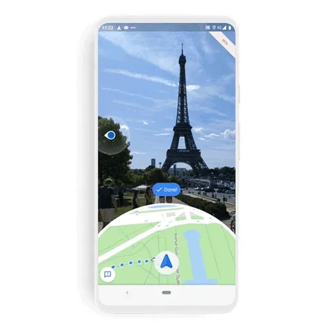
Live View, an AR walking tool that provides direction arrows and distance markers. Google is expanding Live View to include information about landmarks in 24 prominent global cities. The company also says it’s beefed up Live View’s localization and pin placement with machine learning and its topographical view of the world.
More updates: Users can pull up Live View for the walking portions of their multimodal trip, like a short hop from the bus station to the subway. And Google Maps recently added an AR social location-sharing feature for Pixel users to see how lost their friends are on the way to a meet-up. The feature will roll out to Android and iOS “soon.”
Zoom out: I think Google Maps could become a super-app for mobility and travel. But that could be delayed, since we’re sticking closer to our zip codes during the pandemic.
Tech news that makes sense of your fast-moving world.
Tech Brew breaks down the biggest tech news, emerging innovations, workplace tools, and cultural trends so you can understand what's new and why it matters.
By subscribing, you accept our Terms & Privacy Policy.
Tech news that makes sense of your fast-moving world.
Tech Brew breaks down the biggest tech news, emerging innovations, workplace tools, and cultural trends so you can understand what's new and why it matters.
By subscribing, you accept our Terms & Privacy Policy.